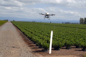
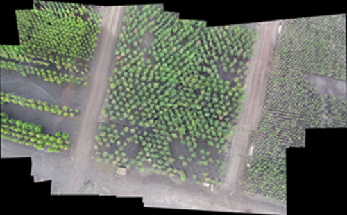
An aerial remote sensing system studied by Oregon State University may provide a new way for the state’s nurseries to check inventories. OSU Willamette Valley trials are underway in conjunction with University of Florida and University of Arkansas researchers at three Oregon nurseries.
Using unmanned multi-rotor aircraft, the team hopes the system will deliver a capability to check inventories of nurseries and Christmas tree farms in the future. If so, growers no will no longer need to estimate inventories, or walk fields to manually count thousands of trees or potted plants.”Many in agriculture feel the unmanned aircraft could play a critical role in the future to monitor crop health and estimate yield,” says OSU researcher Jim Owen.”The team hopes to also use the aerial system to measure plant size and recognize from above regions or patterns of crop stress.”The research is supported by Oregon Department of Agriculture grants, as well as Oregon Association of Nurseries funds.” Nursery containers can be moved every day, and numbers change as plants are removed or sold,” explains Owen .
The remote-sensing vehicle has four or more propellers and looks like a hovercraft. The research team used off-the-shelf technology to attach a digital camera to the unit, which can cost from $2,000 to $5,000 to fabricate.
The Mulit-Rotor Remote Sensing System (MRRSS) being utilized in the current research is capable of vertical takeoff and landing in a manner similar to a helicopter, which allows it to be launched and landed in any terrain. The system is capable to be flown using a commercially available multi channel remote control (R/C) transmitter and has the ability to lift a pay load of approximately 0.9 kg (2 lbs). It used a Lithium Ion Polymer (LIPO) battery as its power source and depending on the load and battery capacity has a flight time of 9-40 minutes. The camera mount installed on the MRRSS platform is controlled by gyros which maintain the camera or other sensing device position in flight. This camera position can be controlled using the R/C transmitter.
The MRRSS control system consists of an on-board and a ground station subsystem. The on-board navigation system, using low cost inertial sensors, pressure sensor, GPS and a single board computer, is capable of providing continuous estimates of the MRRSS in flight position (latitude, longitude, and height above ground) and attitude (roll, pitch, and yaw). The ground station subsystem serves as an interface between a human operator and the MRRSS to implement mission planning, flight command activation, and real-time flight monitoring. The navigation system also accepts GPS waypoints preloaded before flight or in-flight and has the capability to go back to its home position.
The mounted camera/sensor can be triggered at pre-determined interval or by the user using a R/C transmitter. The ability to save and upload waypoints is especially important as it allows temporal comparison with previously collected data. This platform could potentially be used on an “as needed” basis by growers. Other advantages of this platform are its low turnaround time for providing acquired imagery (becomes available after landing the unit); high spatial resolution, and the ability to obtain the image at any desired time point.
It can be operated remotely, but requires some expertise to fly and keep it within low-altitude limits, no more than 400 feet above the ground. The craft can also be programmed to retrieve specific images at precise locations using GPS. As images are collected, a commercial software programme will be used that teaches itself to recognize individual plants and analyze the data. It then separates the target plants from the background to provide a count.
The MRRSS will be applied to grower processes such as inventory management in open field nurseries and Christmas tree farms and monitoring for plant stress in citrus groves, open field nurseries and Christmas tree farms. The current approach to both of these production processes involves manual labor which is expensive, time consuming, and often imprecise. Information collected using this system will provide important information to growers about their crops that will reduce their inventory and labor costs, improve crop marketability and thus, increase overall profitability.
The team has used the approach to count the number of citrus trees in a Florida grove, with an accuracy rate as high as 94%.
The nursery, Christmas tree, and citrus industries are each significantly large specialty crop industries. In 2009, the nursery industry in the U.S. was estimated to have sales of $3.85 billion (NASS, 2009). The #1 state for nursery production was California ($676 million), followed by Oregon ($532 million) and then Florida ($442 million). The area devoted to nursery production in Florida and Oregon was 40,706 acres and 94,250 acres, respectively. Open-field nursery production in the U.S. alone accounts for about 446,196 acres.
The U.S. citrus industry is concentrated in Florida and California, with Florida being the largest producer of citrus fruit in the U.S. Florida has more than 450,000 acres of citrus orchards and an estimated value of $9.3 billion.
Christmas trees are an important high-value specialty crop in the United States, representing $511 million in grower sales receipts in 2006 (USDA, 2007). Based on surveys conducted by the National Christmas Tree Association (NCTA), U.S. consumers have spent over $1 billion annually since 2004 on real Christmas trees. In 2007, almost 350,000 acres of Christmas trees were grown on over 17,000 farms in the U.S. (National Agricultural Statistics Service, [www.nass.usda.gov]). The Pacific Northwest (PNW), North Carolina, Michigan and Pennsylvania led the nation in production of Christmas trees in 2007 (NASS). These five states combined represent 77% of the total U.S. production. Trees are shipped throughout the country to major U.S. markets and exported to Mexico, Canada, Japan, China, Hong Kong, Philippines, Guam and Puerto Rico. In Oregon, yearly harvest is 7.1 million trees that represent a sales value of $111,000,000. This does not include outside benefits such as employment wages and other multiplier benefits.
Sources: Western Farmer-Stockman , Oregon State University


Hi There,
I currently use a large multi rotor UAV platform which carries a selection of imaging devices one of them is the Tetracam MCA6 for multi spectral imaging.
I am very interested in what software you currently use for counting trees and plants etc….if it is not confidential could you forward to me the name of the software package as it would be of great benefit to me
many thanks Colin
Colin, you might like to try contacting Jim Owen who was mentioned in the post:
http://extension.oregonstate.edu/employee/jim-owen?lookup=news