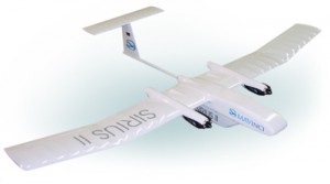
, based in Leimen near Heidelberg, Germany, has announced the introduction of SIRIUS II – a fully integrated orthofoto UAS. The system obtains aerial images and calculates orthofotos and three dimensional elevation models out of the image data.
An orthofoto is a geometrically corrected aerial image such that the scale is uniform. These pictures are necessary for applications such as easy and fast documentation of construction sites, disaster areas, survey of development areas, stone quarries or waste-disposal sites. Other applications are environmental, traffic and wildlife monitoring with MAVinci’s autonomous UAS.
The company specializes in autonomous small aeroplanes with a wingspan of 2 to 5 meters. The MAVinci Autopilot is an in-house development. It allows for completely autonomous take off, flight and landing. All onboard measurement systems run automatically and the accomplished data is stored in an onboard memory. The company’s flight planning software, MAVinci Desktop, simplifies track planning before or during the flight. The complete aerial image process consists of three simple steps: 1. Flight planning 2. Aquisition of Images with SIRIUS II UAS 3. Post processing of the images
The MAVinci Orthofoto System connects all steps to one tightly integrated and user-friendly tool-chain. It comprises a flight planning software licence, a small fixed wing aeroplane equipped with a gauged camera, a ground-station and a post processing software-license.
Typical workflow: The flight planning is done automatically after selecting the aerial image area. Flight plans can be altered before and during the flight. The aeroplane is hand-launched – no catapult etc. is necessary. The maximum flight time of SIRIUS II is 45 min., aerial image mission time is 30 min. Manual control during the flight is possible with full manual or assisted flight mode supported by the autopilot. In this mode landing is possible on very small areas but autonomous landing is also possible. A vertical parachute landing feature will be available soon.
After the flight the aerial images are copied to the post processing computer. The interface between MAVinci Desktop flight planning software and the post processing software Enso MOSAIC enables easy post processing of the images.
Source: Press Release

