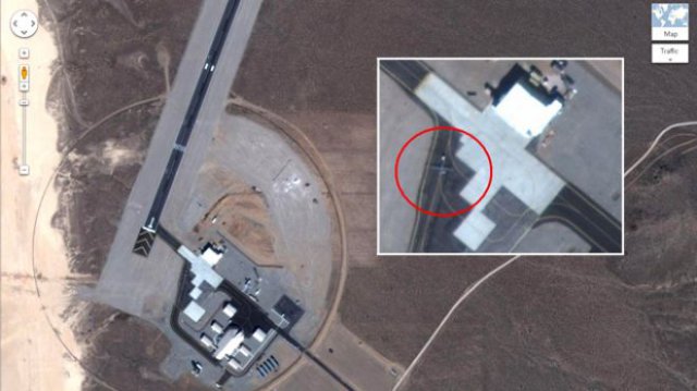
A Google Maps satellite image of an isolated airstrip in Nevada shows a secret but operational unmanned aircraft test facility. The Yucca Lake Airfield, deep inside the heavily restricted Tonopah Test Range, is on land owned by the National Nuclear Security Administration (NNSA), a division of the Department of Energy (DoE), but was constructed and operated by an undisclosed government customer.
The satellite image, taken in early 2011 and available on Google Maps, appears to show a roughly 5,200 ft (1,580m) asphalt runway and what appears to be a General Atomics MQ-1 Predator or MQ-9 Reaper UAV being towed on the parking ramp.
The airfield has four hangars of varying sizes, including a hangar with clamshell doors that is characteristic of US UAV operations. Details of the airfield, including a parking lot, security perimeter and ongoing construction are clearly visible. The hangars could accommodate a total of between 10-15 MQ-9 Reaper aircraft, according to Tim Brown, an imagery analyst with Globalsecurity.org.
Several classified Lockheed UAS, including the Polecat technology demonstrator and RQ-170 Sentinel, were tested at airfields on the range, though the specific airfields have not been disclosed. The RQ-170 is operated by US Air Force units at Creech AFB and Tonopah Test Range airfield, both nearby. Lockheed also manufactures the Hellfire missile, which is standard equipment on US Predator and Reaper aircraft.
Though Predator-class aircraft are operated by several government and military agencies, one construction company involved with the Yucca Lake project lists it as a classified US Air Force installation. Yet Yucca Lake’s isolation from other highly classified sites, including nearby Groom Lake and Tonopah Test Range in Nevada and Dugway Proving Ground in Utah, suggests that even normal military secrecy is insufficient.
One potential conclusion is that Yucca Lake is where the Central Intelligence Agency (CIA) tests hardware and software for its large but classified UAVe programme. The CIA is known to operate Predator-class UAS, amongst others. A covert CIA base at Shamsi, in Pakistan’s Balochistan Province, was publically revealed when satellite images displayed three Predator aircraft and a clamshell hangar at the otherwise isolated airstrip.
The Yucca Lake airfield was constructed beginning around 2002, according to historical imagery of the facility, expanded from a much smaller facility and a small dirt runway. Though official requests for information draw little immediate response, scattered public sources of information are available.
A safety analysis of Yucca Mountain nuclear storage facilities, written by Bechtel SAIC, contains a description of the airfield: “The purpose of this facility is to construct, operate, and test a variety of unmanned aerial vehicles. Tests include, but are not limited to, airframe modifications, sensor operation, and onboard computer development. A small, manned chase plane is used to track the unmanned aerial vehicles.”
Two DoE environmental studies provide further details, including operational details. According to those studies, the base operates four to six UAV flights and two to four manned flights per day, flying mainly over the dry lakebed at altitudes under 12,000ft (3,650m).
The facility can accommodate up to 80 people, and facilities include sophisticated maintenance areas. One study notes that “the nature of the aircraft prevents using normal washing techniques. Aircraft would be wiped down by hand when cleaning is required.” The same document references the construction of “Squadron Operations/Maintenance Facilities”. Predator aircraft, which have a sensitive skin coating, are cleaned by hand.
The runway shares the name and identifier of an old DoE dirt airstrip that was used to support nuclear testing during the Cold War. The larger dirt strip was deactivated in the 1960s, but FAA airfield records still show information for that runway, along with the notation, “owner desires airport not be charted.”
This information would be of interest to the Iranian military, said Cedric Leighton, a retired Air Force Colonel. “Iranians would be most interested in operational bases because that tells them how we fly our surveillance missions,” Leighton told FoxNews.com.
Other Nevada military bases at the Tonopah Test Range like the Creech Air Force Base are also viewable at Google Maps. With this information, anyone — even foreign military — can look up satellite images to inspect secret US spy planes. “Google is making public what was once the sole province of the military and intelligence community, making this a brave new world for the intel agencies as well,” he said. Google did not return FoxNews.com requests for comments.
Leighton told FoxNews.com that Google has the right to show these images to the public, but they should decide not to because they comprise military operations. Most satellite images are delayed and do not show current military research, military sources told FoxNews.com — though none were willing to go into more detail.
Is it legal? The debate over satellite imagery of top secret bases has raged for some time. Previous satellite images showed a secret military base near Denver and in Pakistan’s Balochistan province, where images of the Shamsi Airfield showed Predator drones sitting on a parking ramp, ready for deployment.
Leighton said the U.S. military has previously blocked Google employees from capturing images at military bases for the Google Earth program, which requires close-up photography. Dr. John Michener, chief scientist at security firm Casaba, doesn’t see a problem with Google Maps showing spy plane imagery. He says national laws do not apply above the atmosphere, and the mass public now has access to the same satellite images used by governments for decades.
His advice to the US government? “Get used to it,” Michener told FoxNews.com. “You know when the satellites are overhead. You can take countermeasures to hide portable stuff.” At the same time, Michener says there would be a problem in terms of security if the government decided to filter through “deep-packet inspections,” ultimately inserting code onto the Web that blocked access to secret images. That would drive Google to add encryption to the images — something Michener says may be inevitable.
Sources: Flight Global, Fox News

