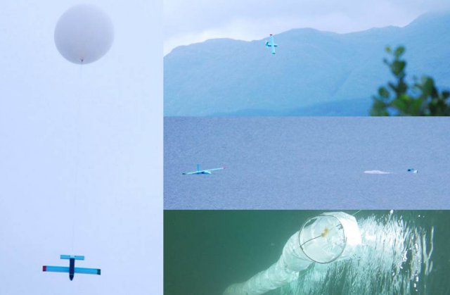
The University of Southampton is developing new unmanned aircraft for science applications and geoscientific research.
The major challenge faced by atmospheric scientists working in remote or hostile environments, such as high altitudes, regions close to mountains or the sea surface and Polar Regions, is the difficulty of obtaining detailed in situ data from these regions using conventional observing platforms.
This autumn, the University will be launching MAVIS (Massive Atmospheric Volume Instrumentation System), a new project funded by the Engineering and Physical Sciences Research Council, in partnership with the Scottish Marine Institute, and with the support of the British Antarctic Survey, the MetOffice and the National Centre for Atmospheric Science.
MAVIS offers the possibility of a flexible measurement system that could open up new possibilities to atmospheric scientists, including more high quality and widespread measurements for accurate weather forecasting and monitoring of pollution and volcanic ash.
At the centre of MAVIS lies an innovative concept for an atmospheric sensing system: a fleet of small, very light, highly bespoke instrumented gliders are released en masse from a high altitude meteorological balloon over the environment to be observed. During their autopilot-guided descent along paths optimised for sampling efficiency, they collect a wide range of readings, which can subsequently be converted into an accurate map of the quantity (such as pollutant concentration) being observed.
Dr András Sóbester says: “The University is home to a wide range of activities in the field of Unmanned Air Systems (UAS) research. From the effective exploitation of state-of-the-art design and manufacturing technologies (including flying the world’s first 3d printed aircraft) to autonomous systems research and from applying multi-disciplinary design optimisation techniques to stratospheric balloon systems, the University has been, for several years, exploring innovative UAS technologies.”
The MAVIS project forms part of the University’s ASTRA (Atmospheric Science Through Robotic Aircraft) initiative, which has pioneered a number of rapid prototyping and low cost technologies in the design of UAS for geoscientific research.
Source: Phys Org

