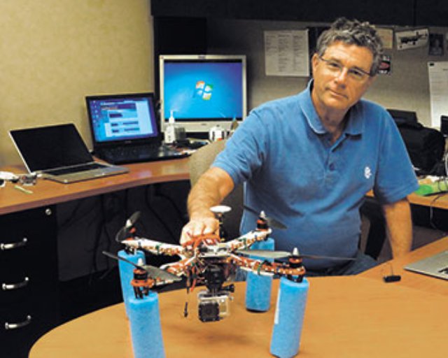
 Richard Evans is IT manager for SpawGlass, a Texas-based general contractor who
believes that using UAS at construction sites an idea that will fly.“These can get in close where helicopters can’t. They will become commonplace in the construction industry,” he said.Since the 1960s, he’s been a dedicated radio-controlled aircraft pilot. About three years ago, he built his first quadcopter using parts such as an autopilot circuit and GPS system. After plenty of positive feedback, Evans built two more.
Features include a stabilized camera, night vision and long-range travel (up to about 16 kilometres one way).
Not including the GoPro camera, it cost him about U.S. $3,000 and about two days to build his quadcopter.
At SpawGlass, his quadcopters were soon capturing valuable footage from the company’s large construction projects.
But San Antonio-based Evans said that most owners and architects aren’t aware of the benefits.
Owners typically hire planes to take a few aerial shots of a project.
“With my quadcopter, I can put it exactly where I want it. I can get close and look at details,” he said.
The drones can also do inspections and spot flaws such as leaks.
Evans predicted that once project managers recognize the capabilities of drones, they’ll want ongoing, weekly or monthly videos to document progress on big jobs.
“You can clarify what was done and wasn’t done,” Evans said, adding that this is important when disputes arise.
Greg Baynton, CEO of the Vancouver Island Construction Association, said there’s already been discussion about doing a virtual tour at a large, complex Island project that is underway.
Typically, site tours are done via bus, which limits what can actually been seen.
A virtual tour, using drone-supplied video, would make sense, Baynton said.
“It’s a very intriguing development that will no doubt find its way into the construction industry,” he said.
An advocate of technology, Baynton said drones have their place at select projects.
“It’s site specific. It would work at big housing developments or remote places like the John Hart Dam,” he said.
Evans had a story about an acquaintance, who owned three lots near a lake.
“He wanted me to fly above his property to see how high he had to build to have a lake view from the upstairs balcony.
“I took a flight above each. The on-screen display showed the altitude at each point. All I had to do was slowly rise from the ground up to about 50 feet, aiming the camera towards the lake.
“On the ground I was recording the camera view and on-screen display info on a DVR. Now we know exactly what the view looks like from each altitude,” he explained.
Drones can range from the large, fixed-wing, weaponized aircraft used by the military to smaller, versatile fixed-wing crafts.
Even smaller are the quadcopters or octocopters (four or eight blades).
The tiniest drones are the size of hummingbirds.
Evans’ drones can operate in cold or hot weather.
He flies them at about 400 feet for no longer than about 20 minutes.
Because they’re electronic, they can’t operate in the rain or in winds stronger than about 30 kilometres per hour.
It is crucial that the operator knows what’s happening with the drone and where it is.
That’s accomplished by mounting a video camera on the drone to allow the pilot to fly as if he is in the cockpit.
Video from this camera is transmitted back to the ground and the pilot can either view it from a screen, or more commonly from video googles.
Pilots can quickly lose perspective of the aircraft direction or orientation when it gets far enough away that and becomes a small blip in the sky.
Wearing goggles is popular because trying to view a LCD screen is hard in sunlight, Evans said.
In Canada, the use of drones is currently limited because they are subject to strict licensing approvals and safety parameters set by Transport Canada.
Drone use in Canada includes scientific research, mineral exploration, police surveillance, border patrol, survey and inspection of remote power lines and pipelines, traffic and accident surveillance, cartography and mapping, search and rescue, agricultural spraying and aerial photography.
Unlike the U.S., drones can be used for commercial purposes in Canada.
But, when used for civil or commercial purposes, the controller must be authorized to fly with a special flight operations certificate issued by Transport Canada.
The Salmon Arm, B.C.-based company Accuas, has been using its unmanned aerial survey fleet since 2007 to carry out surveys and mapping for a variety of industries, including engineering, mining, waste management, oil and gas and agriculture.
Baynton noted that if the skills gap in the construction industry continues to grow, there will be applications for drones.
“Across the country, we’ll look to technology to backstop that gap,” he said.
“There’s a real fit for this technology to carry out monitoring and inspections.”
Source: Journal of Commerce
