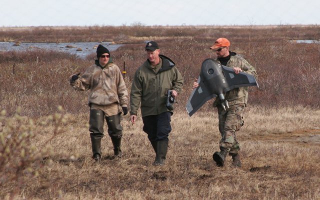
In a portion of Manitoba, Canada, so remote you have to fly in by helicopter, a research team led by the University of North Dakota and the American Museum of Natural History spent the summer in the polar bear capital of the world deploying the latest tool – Unmanned Aerial Systems (UAS) — in a nearly five-decade-old ecological study.
As part of the “Hudson Bay Project,” a collaborative research program that includes partners from the U.S. and Canada, the group conducted nearly 90 test flights from Wapusk National Park to show that UAS can be used to study non-invasively the overabundant geese in the region and their impact on the tundra landscape. In addition to combining effectiveness and efficiency, the single unmanned aircraft used by the team generated more than 80,000 detailed images last June and July—UAS studies are also safer than foot surveys that put researchers at risk of encounters with bears.
“This technology has propelled us well into the 21st century,” said Robert Rockwell, a research associate in the Museum’s Department of Ornithology and a senior scientist of the Hudson Bay Project. Rockwell, who has been counting geese in the area since the late 1960s, teamed up last year with UND biologists Susan Ellis-Felege, Robert Newman, Chris Felege, UAS expert Michael Corcoran, and students Andrew Barnas and Sam Hervey to explore the use of UAS at the remote Canadian camp.
“We have been able to enhance and extend our geographical coverage, and to do it in a way that precludes potential disturbances of the very ecosystem we are studying,” Rockwell said. “It also helps us avoid confrontation with the ever-present bears, the region’s top predators. The first year’s operations were a grand success by any measure, and I look forward to expanding our efforts in 2016 and beyond.”
The team is the first to be given permits to develop UAS technology in a national park in Canada. The new tool allows freedom to monitor the ecosystem from the air and greatly extends the range of monitoring activity, providing the kind of view and access previously only afforded by helicopters, but with much less noise and expense. The researchers’ vehicle of choice is a 5.5-pound Styrofoam flyer that launches via catapult and is programed to follow transects while taking photos at one-second intervals. The imagery is then stitched together to form a picture of the ground below. From about 250 feet up, the aircraft’s belly camera clearly captures snow geese (blue and white varieties) and their goslings, different types of vegetation and damaged areas, and other bird species like sandhill cranes, tundra swans, bald eagles, and herring gulls.
To gauge how the local wildlife responds as the aircraft flies nearby, the researchers placed video cameras near goose and eider duck nests. They found that the animals generally ignored the aircraft, even when in close proximity to the launch sites.
“Once we’re set up, the birds didn’t seem to pay attention to the aircraft,” said Ellis-Felege. “But to confirm nesting bird responses, we are now reviewing camera footage and sound recordings from the nests to determine if they show any responses to this small aircraft flying above them.”
That is important not only to the nature of the work, but also to the park managers and the indigenous people who have a “don’t touch and don’t disturb” philosophy, said Rockwell. “Using UAS allows us to respect those wishes and cultural![]() considerations,” he said.
considerations,” he said.
Before starting the study, the team underwent extensive training to receive a Special Flight Operations Certificate. The flights are conducted through the approval of both Parks Canada and Transport Canada.
“Flight crews, including the biologists, initially received factory training that instructed them how to professionally operate the air vehicle, and they continue to build their science and aviation skills as the project moves forward,” Corcoran said.
The technology does have limitations: the vehicle must be in sight at all times during flight, so helicopters are still necessary to transport the equipment to areas of interest that are far away from the electric-fence-protected camp. But based on their initial tests, the researchers expect that UAS will be extremely beneficial in learning more about nesting and nest failure in the region—an increasingly important topic as the changing Arctic climate is causing bears to consume alternative food sources like geese and their eggs.
Unmanned aircrafts also could be used to study the area’s predators by identifying “day beds,” flattened grass areas that mark where polar and grizzly bears rested on land. Researchers can then go on targeted field trips to collect hair left in the beds for genetic testing that provides details about the local population.
Funding for the study was provided by the North Dakota Experimental Program to Stimulate Competitive Research (EPSCoR) program, UND College of Arts and Sciences, UND Office of the Provost, Parks Canada and Wapusk National Park, the Central and Mississippi Flyway Councils, the Arctic Goose Joint Venture, and Anne Via.
Source: Valley News


The statement in the third last paragraph is somewhat misleading
“The technology does have limitations: the vehicle must be in sight at all times during flight”
Yes the technology is limited, but it is limited in operation by transport Canada’s rule of not flying beyond visual line of sight (BVLOS). The writer of the article failed to mention the UAS used and I will assume there is a reason and not mention it either, but rest assured that the air frame pictured has a one way range of 60 kilometers. As far as the UAS technology involved is concerned, flying to a point 20 KM away, loitering and returning is easily achievable, its just not allowed.