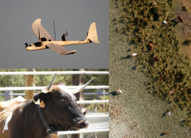
A team led by the Doñana Biological Station, Spanish National Research Council (DBS, CSIC) has used Unmanned Aircraft Systems to model the spatial distribution of free-ranging cattle in Doñana National Park, Spain.
The coexistence of domestic cattle with wildlife species in protected areas has ecological consequences (pressure over the native vegetation) and sanitary implications (i.e. tuberculosis transmission) of importance for environmental research and management.
The work, performed on the frame of Aeromab and Planet projects, was developed in collaboration with the Institute of Research in Game Resources (IREC, CSIC). The flights were conducted with a small fixed-wing UAS assembled in Doñana Biological Station that has been previously used for other environmental applications, such as anti-poaching or power lines inspection. The plane is electric to minimize wildlife disturbance and requires only a small area cleared of vegetation for takeoff and landing, which enables immediate deployment. An onboard still camera gathers images along the flight that are later geo-referenced for GIS processing.
The paper describes a comparison between animal spatial distribution models obtained by two different techniques. One model was built using the locations of the animals detected in images obtained with a small fixed wing UAS along 192 km of flights over the protected area. The other model was built using data from animals marked with GPS-GSM collars that periodically record the position of the individuals. The researchers also tested the usefulness of UAS overflights to predict species densities for a comparison with the actual cattle density in the park.
UAS and biologging (GPS collars) models provided similar spatial distribution patterns. On the other hand, predictions from the UAS model overestimated cattle densities, which may be associated with higher aggregated distributions of this species.
The results of the study demonstrate that Unmanned Aircraft Systems (UAS) have a high potential for the prediction of animal spatial distributions, particularly useful for ecological research, wildlife management and rangeland planning. UAS also present the advantage over the current techniques of being a non-invasive tool that can also provide real time information on habitat characteristics and other species locations.
The paper can be free downloaded from this link:
http://onlinelibrary.wiley.com/doi/10.1002/ece3.1744/full
Mulero-Pázmány, M., Barasona, J. Á., Acevedo, P., Vicente, J. and Negro, J. J. (2015), Unmanned Aircraft Systems complement biologging in spatial ecology studies. Ecology and Evolution. doi: 10.1002/ece3.1744
Source: Press Release

