has announced that its cloud-based platform has been selected by CNH Industrial – a global leader in agricultural equipment and other capital goods – as the software for a unique, all-in-one UAV system. Available now from CNH Industrial’s network of Case IH and New Holland dealers, the bundle includes a one-year Standard or Premium DroneDeploy software subscription, the DJI Phantom 4 Pro drone with RGB camera, and other drone accessories.
“This agreement with DroneDeploy is an important milestone in our continuing, focused effort to collaborate with data and precision companies at the forefront of their discipline,” said Joe Michaels, Director of Global Precision Product Management with CNH Industrial. “This initiative allows us to offer growers what is, we believe, the first truly economical drone and software package for capturing actionable field imagery and analysis.”
CNH Industrial’s new UAV solution is designed to be easy to understand, simple to operate, and is a powerful investment in immediate field intelligence. According to Scott Lumish, Vice President of Business Development at DroneDeploy, “Farmers and producers may not be able to control certain environmental conditions, but drones are an efficient way to mitigate crop health issues and improve yields. The benefits of being able to survey both the 10,000-foot view of fields, as well as zoom in to inches above the plants, are incredibly powerful.”
For example, with DroneDeploy’s platform and sophisticated DroneDeploy App Market tools, growers are making more informed decisions to:
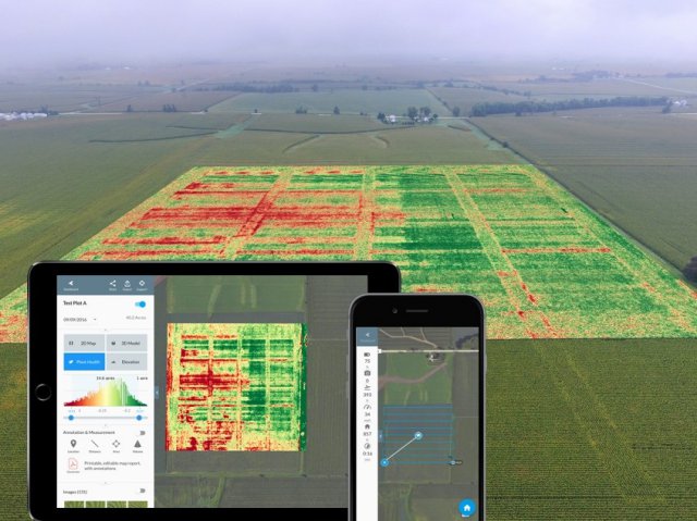
- Crop scout to detect parasites and fungi: Drone mapping helps pinpoint the location and extent of plant health issues, which are illustrated through the DroneDeploy dashboard.
- Generate variable rate prescriptions for nitrogen and pesticides: Drone-generated, zoned shapefiles from DroneDeploy can be exported into popular farm software to generate variable rate prescriptions for nitrogen, pesticides and other targeted nutrient applications.
- Negotiate fair crop loss percentages: Annotated crop health maps, which provide a more accurate picture of crop loss versus the traditional method of walking through small sections of damage, help users with insurance requests and recoup crop losses.
- Assess and clean up after natural disasters: Drone maps can help estimate the extent of storm or tornado damage, and even help when clean-up is needed. A drone map can spot hidden debris, enabling users to plan for more efficient removal.
DroneDeploy’s software allows for intuitive automated flight so owners can fly the field, then view and analyze field maps with powerful filters on the same day. Owners then have the ability to share the data and analysis with trusted advisors for possible immediate action – and even bring maps into the field on mobile devices to ground truth and take notes. DroneDeploy also offers settings that empower users in remote locations to leverage cloud-based drone data insights, without worrying about data bottlenecks and rural connectivity challenges.
“We have seen businesses in every industry leverage our extensible SaaS platform and drone data analysis on job sites to enable faster and better decisions,” said Mike Winn, co-founder and CEO of DroneDeploy. “We believe this joint offering with CNH Industrial marks an important company milestone, and further validates the use of drones in agriculture.”
Source: Press Release

