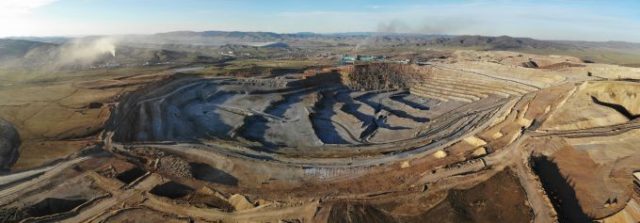
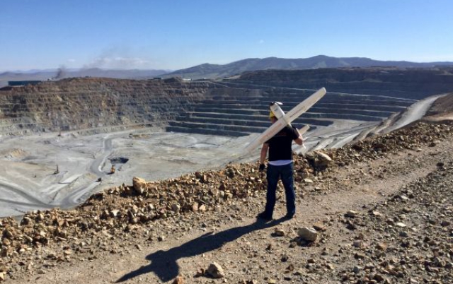
In May 2018, the Erdenet Mine in the north of Mongolia was mapped in just three days. The open pit mine measures 5km by 2km and has an elevation difference of 200 metres. The dusty and complex circumstances called for the use of an unmanned aerial system (UAS).
Despite the strong wind and extremely variable weather conditions, a single UAS quickly captured the geospatial output necessary for the management of one of Asia’s – and the world’s – largest copper mines, as described in this article.
The big data gathered and processed by the Czech firm UpVision provided a perfect overview of the vast location and recorded the exact status of the mine explorations, enabling three-dimensional modelling of the complex site. This was the first time a UAS had been used, but the results were so satisfactory that the method will be used regularly from now on. This will also allow the management to build an overview in 4D; by combining the initial results with future flights, they can easily compare data series over time to predict and record work progress and build a digital 4D archive.
Preparations
The detailed mapping of the mine took two weeks of serious preparation. First, 21 ground control points (GCPs) had to be created and measured in the local UTM coordinate system using GPS RTK. Points had be marked with reflective sprays to ensure visibility during the days of the actual mapping. They had to be rechecked after controlled blasting in the mine and remarked when needed. Next time, more permanent markings will be used in several places. Additionally, it was necessary to carry out exploration of the mine surroundings to find the most suitable landing location for the unmanned aircraft: ideally a length of at least 20-30 metres of grassland. Two such locations were found about three kilometres apart. Seven flights were done from the first landing location and two flights from the second (on a relatively steep grassy slope at the edge of the mine).
One major challenge was to create a flight plan since there are significant height differences in the area around the Erdenet Mine. Therefore, the flight plan for mapping the entire face of the mine was executed at two different image resolutions/flight altitudes. Another big challenge was posed by the weather and climate conditions in the north of Mongolia. The first half of May 2018 was selected as the mapping period since May has minimal rainfall. Even so, the weather was very variable; on some days it was clear and over 20 degrees, but on others there were snowstorms and snow covered the ground control points. Luckily, the snow melted in the afternoon and did not damage the points. In addition to temperature fluctuations, the biggest problem for the UAS was that the mine is located at an altitude of about 1,400 metres above sea level and a persistently strong wind prevails, reaching up to 20m/s during the day. The wind also creates a lot of dust in the air around the mine. But thanks to the long days in May, with good lighting conditions, the flight schedule could be adapted to flying several missions in the early morning (6:00-8:30h) and in the evening (18:00-20:00h). The mission took nine mapping flights during a total of three days, usually with two flights in the morning and two in the evening depending on the weather conditions. The duration of each flight did not exceed 30 minutes because of the increasing strength of the wind.
Data capturing and processing
More than 10km² of the mine and its surroundings were mapped from the MaVinci Sirius unmanned aircraft. UpVision has been using this UAS for more than five years for missions in difficult terrain, not least because of its manual flight mode and the possibility to repair the UAS immediately on the location. The camera used was a Panasonic GX1. The overlaps between images and rows were 80/70%. The image resolutions from the two flight heights were between 4 and 10cm/pixel.
Raw data matching was performed directly on location after each completed flight, which took just five minutes using the MaVinci Desktop planning software. The minimum necessary overlaps for the orthophoto and the digital surface model could easily be verified through visual control of the aerial images. Almost 7,000 aerial photographs including the external orientation were processed and computed in several blocks in Agisoft Photoscan Pro software.
The main output of the aerial mapping was the detailed digital surface model in the form of a textured point cloud, formed by 400 million points in the local UTM coordinate system. Geologists primarily use the digital mine surface model in software with which they can analyse the slopes and walls for potential stability problems. Other outputs were orthophotos in various image resolutions for detailed mine coverage. For this, some extra flights were performed using a very small UAS (DJI Mavic Air) for highly detailed vertical documentation of the mine walls. All the data will be used to build a 3D mine model to create cross-sectional and longitudinal profiles of the mine as a basis for the planning of further mining operations.


The Erdenet Mine and Czech geologists
Geographically speaking, Mongolia is bordered by China to the south and Russia to the north. Why is UpVision from the Czech Republic mapping a copper mine in Mongolia? That is not as strange as it seems. The copper deposits were found in the 1960s by Czechoslovakian geological expeditions. Mine mapping has always been an important output of these geological expeditions, which the Czech Republic continues to operate to this day. The mine was established in 1978 with the help of the former Soviet Union, of which Czechoslovakia was then part and with which Mongolia maintained close links. Today, it is one of the biggest ore mining and ore processing facilities in Asia. The complex processes 26 million tons of ore per year, of which around 530,000 tons of copper concentrates and around 4,500 tons of molybdenum concentrates are extracted annually. The mine accounts for a substantial part of Mongolia’s GDP and tax revenue.
Source: GIM


