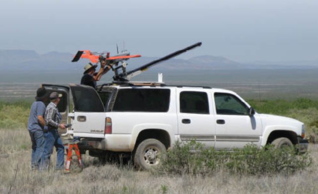
At Jornada Experimental Range in southern New Mexico, ongoing research is aimed at determining the utility of UAS for rangeland mapping and monitoring and developing an operational UAS-based remote sensing programme for ecological applications.
USDA scientists Al Rango and Andrea Laliberte are leading a team to conduct ongoing research at the USDA Agricultural Research Service’s (ARS) Jornada Experimental Range in southern New Mexico. The goal of this research is to determine the utility of UAS for rangeland mapping and monitoring and to develop an operational UAS-based remote sensing program for ecological applications. Over the last five years, they have developed workflows for acquisition, processing, and analysis of fine-detail UAS imagery and for relating remotely sensed information to ground-based measurements.
They are currently operating two BAT 3 unmanned aircraft (acquired from MLB Company in California). The BAT system consists of a fully autonomous GPS-guided UAS with a six-foot wingspan, a catapult launcher, ground station with mission planning and flight software, and telemetry system.
The UAS carries three sensors a colour video camera with live video downlink to the ground station, a Canon SD 900 10-megapixel digital camera, and a multispectral camera (from Tetracam, Inc., another California company) that acquires images in six narrow bands ranging from the blue to the near infrared.
The UAS is launched off a catapult and can be landed autonomously or manually via radio control. They fly generally at 700 feet (213 meters) above ground level, which results in a nominal ground-resolved distance of six centimeters for the Canon imagery and 14 centimeters for the multispectral imagery.
Imagery is acquired with a forward lap of 75% and side lap of 40% for photogrammetric processing into seamless image mosaics. The onboard computer records a timestamp, GPS location, elevation, pitch, roll, and heading for each image.
There is a growing interest in using UAS for remote sensing applications in natural resources. At the Jornada, scientists have found that UAS show great promise for remote sensing of rangelands due to the low flying heights, resulting high-resolution imagery, and lower image-acquisition costs per image compared to manned aircraft.
In addition, the ability to fly over a study area multiple times in a season and at multiple flying heights offers great opportunities for change detection studies. Current limitations include initial acquisition costs for the UAS, crew training requirements, limited availability of high-quality and lightweight sensors, and FAA regulations for operating a UAS in the national airspace.
Read the complete story here.
Source: Professional Surveyor

