UK tech startup Altitude Angel is a drone cloud services company offering enhanced situational awareness information, real-time ‘air traffic control for drones’, as well as plug-in geofencing data targeted at manufacturers and developers. It has now unveiled a global airspace monitoring system that promises to help drone operators fly more safely and responsibly – Airspace Alerts.
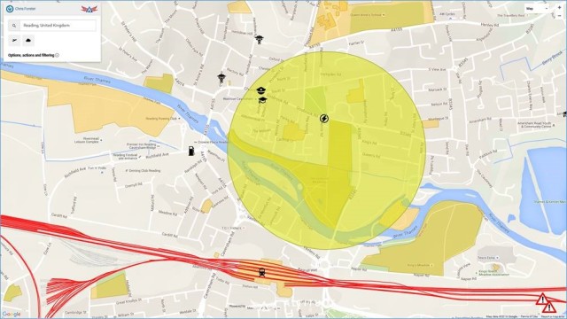
The new software, the world’s first, enables drone operators to specify ‘alert regions’ that the firm’s cloud platform monitors in real-time for low-flying manned aircraft, proactively sending a push notification via email or SMS to the drone operator to ensure they have time to move out of the way safely. The service will soon also send out important weather information, as well as alerts whenever no-fly zones are activated or deactivated.
Combined with its free Drone Safety Map that helps drone operators identify no-fly zones or ground hazards around the world before they ‘take to the skies’, the firm believes its new Airspace Alerts service will contribute towards the safer integration of drones into our skies. Being able to ‘reach out’ to push important information to a drone pilot is absolutely critical to safety.
The technology watches aviation traffic globally in real-time, aggregating data from multiple sources. It receives around 12 million messages every minute, which are then filtered to provide updates on low-altitude air traffic (below 800m) – the kind that drone users need to be aware of.
“Once we have a filtered set of aircraft data, we perform analysis to determine if the aircraft’s trajectory is likely to encroach on an area our users are flying within, and can tell the drone operator where to look – and when – to help them avoid being in the wrong place at the wrong time,” says Richard Parker, founder and CEO of Altitude Angel.
The Airspace Alerts service is launching at a time when even the Queen has raised concerns about drones, and there are calls from the Civil Aviation Authority (CAA) and the British Airline Pilots Association (BALPA) to introduce regulations following “a spate of serious near-misses“. Under current legislation, drone operators and enthusiasts are personally responsible for making sure they are flying drones safely and complying with a variety of other regulations, which are often too complex for general drone pilots to understand.
“Drone pilots everywhere are crying out for better information,” said Parker. “The majority of people want to ‘do the right thing’ and check for no-fly zones, obstacles and relevant regulations before they fly, but many don’t have the training, time or even access to everything they’d need in order to make better safety choices. It’s the industry’s job to help solve this problem.”
“In light of the ever-increasing use of unmanned aerial systems, and the extremely important legislation that covers their use, this is a great way to enhance aviation safety and to help operators become responsible aviators in this exciting and fast-moving industry,” said Zander Cornish-Moore, operations and marketing manager at AM-UAS – one of the UK’s leading CAA approved operators of Unmanned Aerial Systems.
Although Altitude Angel’s longer-term mission is to deliver safety and navigational data directly to automated drones, they are very much focused on empowering their human operators today to access fresh, relevant safety data as well as useful monitoring to reduce the risk of a serious incident occurring.
“The more we can do to help drone operators identify risks, and minimize the chances of a collision between a drone and a manned aircraft, the more we increase safety, and the chances of the drone industry flourishing,” said Parker.
The Altitude Angel team, made up of ex-Microsoft cloud services developers and consultants, created their own software and have spent more than six months testing as well as working with regulators, manufacturers and user groups across the USA and Europe.
Source: Press Release

