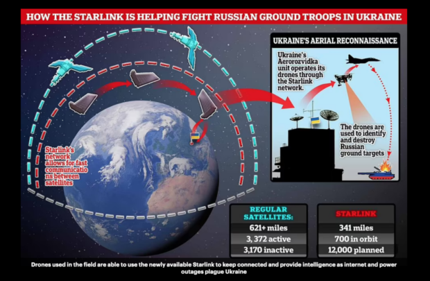
Elon Musk’s Starlink satellite system is helping Ukrainian forces in the drone war as the nation fights back with technology to track down invading Russians. Continue reading


UAS VISION
an independent online news service for the Unmanned Aircraft Systems world

Elon Musk’s Starlink satellite system is helping Ukrainian forces in the drone war as the nation fights back with technology to track down invading Russians. Continue reading

General Atomics Aeronautical Systems, Inc. successfully tested advanced datalink capability as part of a U.S. Army-funded development effort to upgrade the MQ-1C Gray Eagle Extended Range Unmanned Aircraft System . Continue reading

AURA Network Systems and the Federal Aviation Administration have entered into a four-year Cooperative Research and Development Agreement (CRADA) to help determine performance standards for Air Traffic Control (ATC) voice communications supporting unmanned aircraft systems within the national airspace system (NAS). Continue reading

Chantilly, Virginia-based Fenix Group Inc. was recently awarded a contract via Nokia Corporation and the Defense Innovation Unit (DIU) to deliver citizen broadband radio service (CBRS) private cellular backpacks to the California National Guard to provide resilient communications during disaster response. It will solve the command and control (C2) problem in disaster and austere environments, and get drones flying on a common network. Continue reading

On November 18, 2021, General Atomics Aeronautical Systems, Inc. (GA-ASI) used two company-owned Avenger Unmanned Aircraft Systems, each equipped with a Lockheed Martin Legion Pod, to send long-range air threat data captured passively and fused by an advanced sensor algorithm to a Command Center. Continue reading
uAvionix announced the successful completion of the first series of flights with its newly developed SkyLink Control & Non-Payload Communications (CNPC) C-band radio, intended to meet the needs of safety-critical & BVLOS missions as well as operators and manufacturers with airframe certification in mind. Continue reading
Governor Kathy Hochul announced that the MITRE Engenuity Open Generation 5G Consortium will bring 5G to the New York State 50-mile unmanned aircraft systems corridor between Syracuse and Rome. Open Generation has determined this corridor is a prime location to launch the nation’s first 5G unmanned aircraft systems testing range, a designation that will greatly enhance New York’s position as a global leader in this emerging technology sector. Continue reading
Hughes Network Systems, LLC and SES have announced the successful first demonstration of a new multi-orbit satellite communications (SATCOM) capability for remotely piloted aircraft. Conducted for General Atomics Aeronautical Systems, Inc. (GA-ASI), the demonstration paired Hughes HM series software-defined modems and Resource Management System (RMS) with SES’s satellites that operate in geosynchronous (GEO) and medium earth (MEO) orbits. Continue reading